Creekmouth Movers Lane / River Road (490010105W2)
Colebrooke Street (490016787N)
Date: 24/10/23
Wrong Bus Stop Positions:
-
Manordene Road (490009550N)
-
Humphrey Street (490013339S)
-
Movers Lane / River Road (490010105W2)
-
Colebrooke Street (490016787N)
-
Marischal Road (490009656W)
Thanks @Ajebz @petejackson745
We’ve corrected the first 4 on your list and these should be in this week’s data build.
While looking at Marischal Road, we’ve also noticed the Belmont Hill stops (490003864M & 490003864N) are in the wrong location.
These should hopefully be corrected in that build.
Thanks,
James
Date: 3/11/23
Bus Stop Positions Fixed:
-
Manordene Road (490009550N)
-
Movers Lane / River Road (490010105W2)
-
Colebrooke Street (490016787N)
-
Marischal Road (490009656W)
-
Belmont Hill (490003864M & 490003864N)
Removed From Thread:
- Humphrey Street (490013339S)
Southfield Close Stop CR (490012289S)
Harlington Road Stop UC (490005539E)
Coney Green Stop UM (490005539W)
The Greenway Stop BD (490013396E)
St Andrew’s Church Hillingdon Road Stop Y (490012425S)
Hatton Road North Stop K (490010377F)
Bedfont Library (both 490003790E & 490003790W)
Browells Lane Stop FW (490004503E)
Lower Teddington Road Stop H (490009430K)
Kingston University Penrhyn Road Stop N (490008829N1)
Carlton Grove Stop QD (490004799QD)
Hertford Road Stop D (490006348W)
Oakhurst Road Stop B (490009539S)
Enfield Crematorium Stop A (490006580N)
Ladysmith Road Carterhatch Ln Stop D (490005985W)
Linwood Crescent Stop L (490005985E)
Dearsley Road Stop G (490003544S)
Great Cambridge Road Stop R (49000739600)
Cecil Avenue Stop L (490004902W)
These are on top of the errors that I have reported at Heathrow on my other thread.
Just checking if you got these?
Hi @petejackson745 - thanks. We’ve seen these but they are still in the queue to be looked at. We’ll let you know once the relevant amendments have been made.
Many thanks,
James
Most of the issues above got resolved, 2 stops however got amended but are still in the wrong place
Stops which were changed but are still out of place:
The Greenway Stop BD (490013396E)
Enfield Crematorium Stop A (490006580N)
Heres some new finds:
Hervey Road Stop T (490010537E)
Moorhead Way / Pinto Way (490020132S)
Woolwich Manor Way Newham Way Stop BS (490008191W1)
All Saints Church Stop S (490003245W)
Horse Leaze Stop A (490008378S)
Dearsley Road Stop C (490003544N)
Bush Hill Road Stop W (490005306N)
Cambridge Roundabout / East Side Stop EC (4900000000)
Denleigh Gardens St Paul’s Church (490002229Z)
Heathrow Terminal 5 Stand 8 (4900164309)
Heathrow Terminal 3 stops (various. Stops are mostly in the wrong place)
Heathrow Terminal 5 stand 8 (4900164309)
Wrong stop names:
Travelodge Heathrow Central (490020182E) should be Ibis Budget
Park Inn Hotel (490020172S) should be Raddison/Raddison Red.
Heathrow Central Bus Station Stand 8 (4900080168) should be renamed to Coach Stands (Coach stands now seem to be dynamic rather than set, as such this should be better reflected in NAPTAN.
Missing stops
Heathrow Terminal 2 (Missing stop 11 for RailAir)
Heathrow Terminal 3 (Missing stop 7 for RailAir and 13 for Hotel Hoppa)
Heathrow Terminal 5 (Missing stop 7 for Hotel Hoppa and 13 for RailAir)
Heathrow Moxy (For Hotel Hoppa)
Heathrow Stalybridge Suites (for Hotel Hoppa)
Heathrow Courtyard Marriot (for Hotel Hoppa)
Heathrow T4 Holiday Inn/Crowne Plazza (for Hotel Hoppa)
Heathrow T4 Premier Inn (for hotel hoppa)
Hi Pete - Dr J from DfT here - I’m working with Dave Mountain and the Heathrow Airport team to sort out their bus/coach stops.
I think we have these on our list for our meeting next week - if not I will ensure we add them.
We have some ideas for how to fix the coach stops - there’s a complication too about the axels (can’t have two three axel coaches side by side… apparently they can’t turn around each other) and there are some “Bus Only” stops where a coach would be … stuck if it used it.
We also wanted to ask - and I think you have given me some of the information - if we need to include the “Shuttle Buses” - assuming Hotel Hoppa is a “Public service” and not only for people who have booked into those hotels…
Cheers
Dr J
Hotel Hoppa is a completely public service open to everyone, not just for those booked into the hotels (albeit that may be their primary market)
Coach stops, for Central Bus Station, rather than giving a stand number, just put a collective ‘coach stands’ as the stand numbers can change each day and aren’t advertised in advance. A single coach stands stop would suffice, that is the exact same as how Manchester Chorlton Street Coach Station, Digbeth Coach Station and Victoria Coach Station works on NAPTAN.
Other stops should be fine to put in and treat it all as a normal bus station with the stands and whatever as the stands are set in stone for each departure.
Hope that helps.
Oh wow, this is a formidable thread!
Some more to add to the list:
- Southall Station Stop O (490001255O)
- Edge Hill Stop L (490006419E)
- Spencer Hill Stop U (490012378W)
- Wimbledon Tennis Club & Museum Stop A (490016252N)
@HandyHat
Where exactly is the location error? My app puts those NaPTAN lat/lon values into Google Streetview and all 4 stops are displayed correctly.
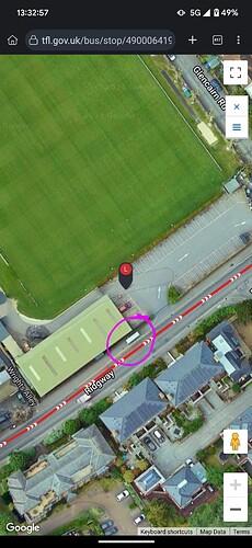
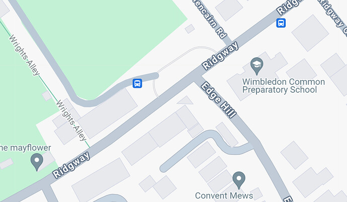
@misar They are incorrectly positioned on the TfL site (and I think in the open data, because consumers like Google Maps also have the incorrect location) - e.g. Edge Hill should be further south.
I didn’t think to check the NaPTAN database!
As you say the map co-ordinates from the NaPTAN entry are slightly off target
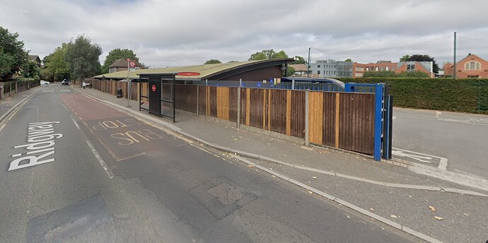
but Streetview finds the stop correctly, presumably because their closest image is taken from the Ridgway
However, I have often noticed stops in slightly the wrong place on Google maps so possibly the stop co-ordinates have a significant +/- uncertainty. This would not be inherent in the co-ordinate system because the stop locations use 12 figure co-ordinates which locate a point on a map to an accuracy of 1 square metre:
Naptan_Atco easting northing latitude longitude
490006419E 523575 170457 51.419666 -0.224208
Edit
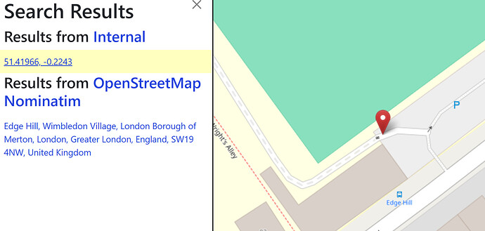
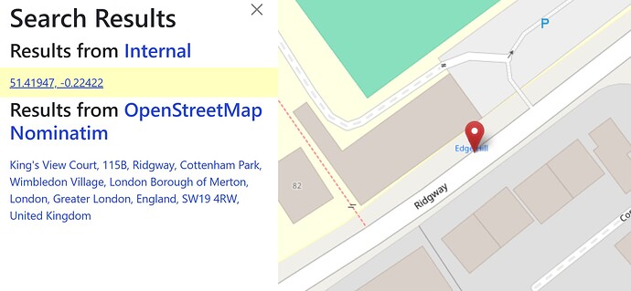
Some research with OpenStreetMap reveals it shows the correct location and the NaPTAN one is indeed wrong:
These are all great examples - we think there are some problems with the data flow - as the Eastings/Northings seem to be right (ish) in NaPTAN - and TfL doesn’t in NaPTAN convert the E/N to Lat/Long - so whoever is doing that Lat/Long is either misconverting or moving the stop
We are doing a deep dive into Data Quality for NaPTAN - and the “Where” is an area we are gathering information on across all the ecosystem to figure out where the “where” is going a bit off piste.
Open Street Map (OSM) has a “snap to roads” which can move some stops unintentionally quite some distance from their intended spots. We know some of the Local Authorities have battles with this (TfL might not)
@drjharrison As you say the TfL NaPTAN entries provide only the stop grid references. In view of this I maintain my own version of the NaPTAN database in which I convert them to lat/lon values using an online batch converter (Coordinate conversion). It was those values I used for Edge Hill (Stop L) in my previous post. Following your comment about accuracy I have checked them with the BGS converter (Coordinate converter | British Geological Survey (BGS)) and got identical values (51.419666,-0.224208). They are also the values used by Google Maps for the stop.
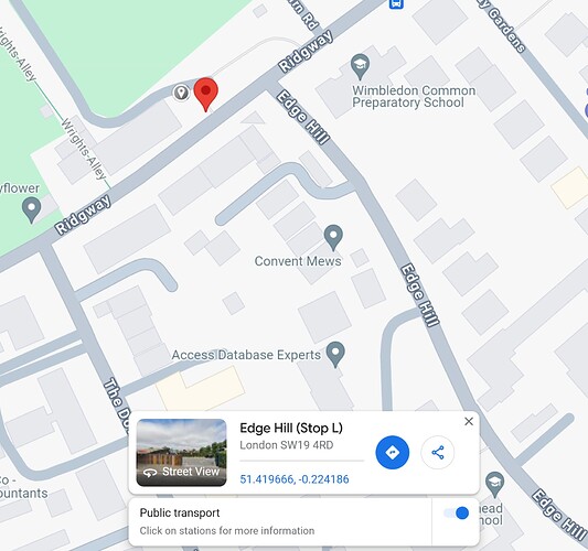
I have also been preparing TfL stop databases using the JSON output from the API and that provides lat/lon values instead of a grid reference. I did not think to check them previously but the values for that stop are 51.419602,-0.224047 which Google locates as the correct stop position (the red marker below). Hence, it appears that there is an issue with the stop locations provided to NaPTAN but not with the API, at least for Edge Hill (Stop L).
PS
To be sure the NapTAN has not been updated recently I have now downloaded a new copy of 490Stops.csv. It still locates that stop at 523575,170457 with the ModificationDateTime as 2015-06-03T11:40:09.
It’s interesting that the JSON output from the API is correct - as a regular user of Edge Hill (L), I can say that at least for Google Maps, the location used to be correct!
It changed in July 2023 - perhaps Google Maps changed data source?
Hi Dr J,
How did you get on at the meeting? Sadly these issues, as well as stops still in the wrong locations, still exist.
Hey Pete,
Conversation was good - it’s not a short solve issue. We’re going to have more conversations post Easter with everyone involved in getting the data from TfL to Google Maps and see where we can improve.
We’re also working very closely with teams involved in Heathrow stops to improve the layouts there - there have been two physical audits (which slightly differ of course) and we’re working on getting those stops named and aligned.
If it helps (possibly not) TfL is not the only LA with issues - we are also working with Bristol to sort out Bristol Temple Meads stops.
Thanks for the prompt to keep you informed on progress.
Hi Dr J,
Thank you for your reply. I’m glad to hear that there has been some positive conversations had. I look forward to seeing some solutions, hopefully in the near future.
Thank you, Pete.
