I think the “one minute” might be a bit of an under-estimate for the interchange. 
For now, matching the 5-minute service with the 7-minute service is going to mean in practice that the service is going to be hard to calculate!
I think the “one minute” might be a bit of an under-estimate for the interchange.
For now, matching the 5-minute service with the 7-minute service is going to mean in practice that the service is going to be hard to calculate!
hi @smsm1
Google Maps are not using any interchange values we have set and I believe they set these themselves.
I would suggest providing feedback on the journey to them so they can set a more realistic interchange at Liverpool Street.
Thanks,
James
I see the API is now sending data for the Elizabeth line. I’d assumed the id would be ‘elizabeth-line’, but it’s actually ‘elizabeth’.
Hi @lpgm
You are quick off the mark, we literally just released it.
the mode is elizabeth-line and the line is elizabeth
/Line/Mode/elizabeth-line/Route is still being rejected: “The following mode is not recognised: elizabeth-line”
I note that there is now a message on Twitter
where the sections of the line are being called Elizabeth Line west, central and east. Is this something we’re going to see in the API and be expected to use?
B
Hi @briantist
There will be no labelling as east, west or central in the API.
All the services are being grouped as 1 line with 4 (soon to be 5) routes in each direction:
Paddington (low level) <-> Abbey Wood
Liverpool Street <-> Shenfield
Paddington (high level) <-> Reading
Paddington (high level) <-> Heathrow T5
Paddington (high level) <-> Heathrow T4 (when services restart)
Disruptions will be shown against the stations that are affected.
This behaviour is the same as seen on the London Overground.
In future phases of the opening, we will provide the updated routesections (e.g. Abbey Wood <-> Reading)
Thanks,
James
Thanks, that is useful.
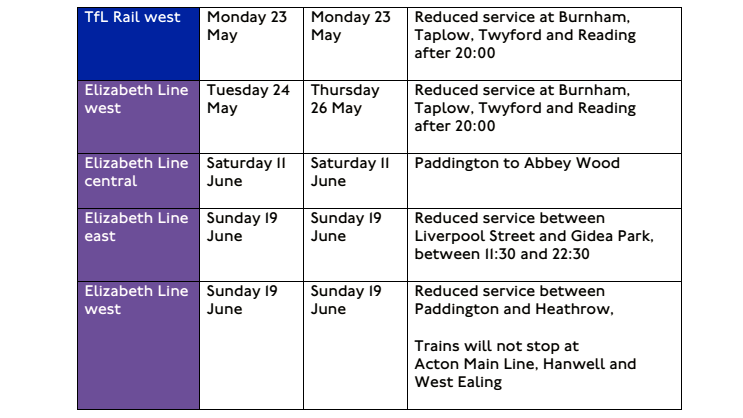
However, the west/east/central names are in use in this TfL document: https://content.tfl.gov.uk/planned-track-closures.pdf
I understand. That’s a manually produced document I believe.
Thanks,
James
@jamesevans the journey planner results seem to miss the “lineString” for the elizabeth line leg under “path”.
Thank you
Anybody have any success getting the stoppoints using the API, e.g.
Hi @nakkore
We found that issue too. We’ve raised it with the software vendor of the Journey Planner back-end who are investigating
Thanks,
James
Just to be crystal clear - does that mean early morning on the 24th but “before launch” because no trains have run yet?
Some functions will go live automatically at midnight, but some we are releasing manually between 1:30 and 3.
Thanks,
James
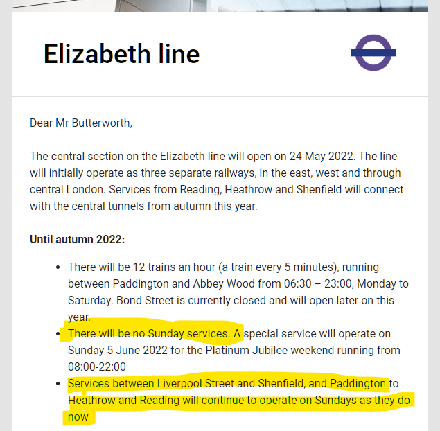
This seems a bit of a disappointment in logic in the email I just received. “There will be no Sunday service” is unqualified. They mean “between Abbey Wood and Paddington” but didn’t say so!
Sorry, just trying to help!
Hi everyone,
Our releases are now complete and the Elizabeth line is live in the Unified API with the changes Joe has mentioned above.
Thanks,
James ‘Zombie’ Evans
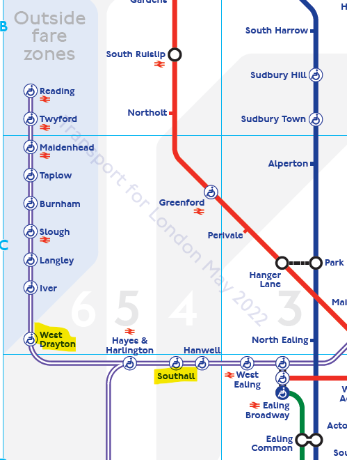
There’s [an error on the tube map](file:///C:/Users/brian/OneDrive/Desktop/standard-tube-map.pdf). West Drayton and Southall have GWR services and should have the red National Rail icon…
The NRE’s dataset doesn’t show the StepFreeAccessCoverage->WholeStation for Southall, Hayes & Harlington and West Drayton.
I’m presuming that the tube map is right here.