Submitting this query https://api.tfl.gov.uk/journey/journeyresults/51.45862944,-0.19276465/to/51.474947,-0.182823 to the journey planner returns this short walking leg in the results
"lineString": "[[58.70179970291, -8.91196339239],[51.47472740438, -0.18313389282],[51.47465060235, -0.18282014910],[51.47476587181, -0.18271476960],[51.47483687544, -0.18265434841],[51.47486339027, -0.18262449491],[51.47487237725, -0.18262413774]]",
The first lat lon is clearly erroneous and makes what should be a short walking leg of a few metres, over 600 miles long! I suspect an erroneous lat lon for a point of interest. Could someone take a look?
Many thanks
Welcome @davemountain
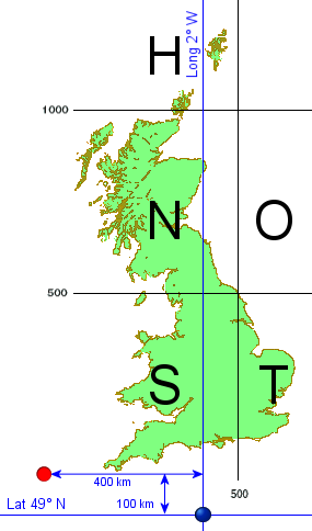
Interesting 58.70179970291, -8.91196339239 seems to match the top right of the UK national grid N square.
Could a null, empty or zero (X,Y) in OSGB transformed into lat, lon. I am reluctant to start accounting for this client-side - looks like something that needs fixing at source?
@davemountain Of course!. I just thought it was interesting that the software seems to internally use the GB grid and then output Lat, long. Given how tricky the maths is* (and I love maths).
Let’s ping @jamesevans and see if he can advise.
- except in postgres when it’s easy but slow!
Hello, thank you for reporting this issue. We have identified an anomaly in our source data, which we are now investigating. I will report back here when I have news. For reference, this has been logged as ticket #91217.
1 Like
Hi Leon
I had an email saying the issue had been resolved, but I can still see the erroneous lat/lon (58.70179970291, -8.91196339239]) in the response to this request https://api.tfl.gov.uk/journey/journeyresults/51.45862944,-0.19276465/to/51.474947,-0.182823
Just checking in on this e.g. if we have to wait for a deploy, or if a different fix is required here?
Many thanks
Dave Mountain
Hi Dave,
Apologies for the confusion. We took some steps to try to resolve the issue, and I thought this had fixed the problem. However, when double-checking it, I realised the issue was still present.
We are working with our supplier to determine what is causing these strange coordinates, and I will update here when I have news.
Hi @davemountain, I believe this is now fixed. Please let me know if you continue to see erroneous coordinates.
@LeonByford I don’t think the fix went to prod straight away, but it does now appear to be resolved
Best wishes and thanks
Dave Mountain
1 Like