Is the London Overground now part of these APIs?

From Briantist

When I created https://twitter.com/OvergroundBot I had to use NR’s Darwin app?

Does this also mean that there is a full set of Station in the data? When I did this heatmap – http://tubedreams.london/london-heatmap/ – I had to scrape Wikipedia for the missing station locations.

Hi Briantist,

Yes, London Overground is included, here are some examples:

Stops with name, location and facilities:
https://api.tfl.gov.uk/Line/london-overground/stoppoints

Route Sequence and geometry line string:
https://api.tfl.gov.uk/Line/london-overground/route/sequence/outbound

Service arrival predictions:
https://api.tfl.gov.uk/london-overground/arrivals

There is full set of station data which includes lat/lon and facilities:
https://api.tfl.gov.uk/Stoppoint/mode/tube
https://api.tfl.gov.uk/Stoppoint/mode/dlr
https://api.tfl.gov.uk/Stoppoint/mode/tflrail
https://api.tfl.gov.uk/Stoppoint/mode/overground
https://api.tfl.gov.uk/Stoppoint/mode/river-bus
https://api.tfl.gov.uk/Stoppoint/mode/bus

You can also do a free-text style search e.g. for stops , e.g. “Bank”

https://api.tfl.gov.uk/Stoppoint/search/bank

Or limit the search by mode, e.g tube and bus

https://api.tfl.gov.uk/Stoppoint/search/bank?modes=tube,bus

I hope this helps.

Is there a Url which returns a list of Overground lines? The one below only displays service status. Thank you.

https://api.tfl.gov.uk/Stoppoint/mode/overground/status

There is only one Overground Line. It’s called “London Overground”.

1 Like

Aren’t there multiple branches? I see it’s not the same as for the tube lines. There, https://api.tfl.gov.uk/line/mode/tube/status returns a list of lines as well as service status. Thank you.

If you use https://api.tfl.gov.uk/line/mode/overground/status it will show the status of the whole of the London Overground. This may be segmented to report sections of lines out of service, but the internal TfL sub-line representations used by Arriva Rail London are not part of the public description of this service. The “branding” as it were for the public is of a simple single service.

This is like the District line, which is two services one from Upminter to various destinations and the “Wimbleware” Wimbledon to Edgware Road. The Central Line is actually now run with Woodford to Hainaught as a separate shuttle service. None of these things are told to the public, which is why the Overgorund is a single line.

So, can you get a list of stations, and the answer to that is “yes”, it’s

https://api.tfl.gov.uk/line/mode/overground/Route

https://api.tfl.gov.uk/swagger/ui/index.html?url=/swagger/docs/v1#!/Line/Line_RouteByMode

The irony is that several chunks of LO have had their own names for years - North London Line. East London Line (though that is stretching it a bit now), Goblin etc. Even the Enfield Town line was known as the Jazz Train decades ago (the name having been resurrected for a time as marketing tool in the '80s IIRC)…

The District is a bit different as Wimbledon trains run to both Edgware Road and Upminster, so there is a sunstantial common system. Rather like the former East London line, with plenty in common between branches and plenty not.

It does seem bizarre though not to have any distinctions at all, bith for marketing and information purposes.

But… arguably not. TfL naming is to do with having a constant brand for these services. This means that the trains:

  • Turn-up-and-go
  • Within the London zones system (and only 2.5 stops are in Zone 1)
  • Walk though trains
  • Tube-train like seating
  • Orange, orange everywhere
  • Staffed stations, from the first service until 15 mins after the last

For most people using the service, it matters not if it’s the Goblin or East London Line or West London Line, they are only going a limited number of stops before they change onto another TfL brand.

It actually quite a rare thing that you can change from one of these lines to another (Willesden Junction, Gospel Oak, Cannonbury, Clapham Junction and Dalston Junction) and so the signage is really good at these stations.

The main problem they comes from this is when a lorry hits a bridge carrying one of the lines, how to communicate this without saying a line name.

Given how popular the Overground has been over the years since it was set up, I would venture that this “branding” approach has worked well for Londoners.

It’s not a forum issue really but to me LO and LU are both top level brands, with the LU lines sub-brands within LU and I see no reason not to distinguish LO lines in the same way. OK, none of this stuff matters for regular passengers but for prospective occasional users the route diagrams are difficult to follow.

BTW the daytime frequency on the Enfield and Cheshunt branches is half hourly, so not turn-up-and-go.

But yet one of the most successful public transport launches in the world! And “occasional users” do seem able to use it given “Increased customer numbers from 33 million in 2008/09 to more than 189 million in 2016/17” - London Overground celebrates 10 successful years - Transport for London

BTW the daytime frequency on the Enfield and Cheshunt branches is half hourly, so not turn-up-and-go.

But they are every 15 minutes as far as Edmonton Green. And the Metropolitan line has trains every 30 minutes at Chesham and Amersham, the Central line is every 20 between Woodford and Hainaught, Acton Town to Rayners lane on the Piccadilly is a low level of service too.

As I said, it’s a about the “brand” and it works for 200 million people a year (BC). It also works for the developers who jump at the chance to build next to Overground stations when they ignored them before.

I agree it has been a great success (fuelled by new links and lots of investment of course) but that does not mean that it could not have been done better then or that it could not be improved now. The relevance on this forum is to the way that passenger information is labelled, on which I imagine we agree.

My Enfield point was in response to you saying that turn-up-and-go was part of a constant brand.

Right, there IS a way to sort this out, and make it consistent and easier to use for casual users, and that’s to change the lines to

  • Line A for former circle line
  • Line B for former bakerloo line
  • Line C for former central line
  • Line D for former district line
  • Line E for former tfl rail
  • Line H for former hammersmith and city line
  • Line J for former jubilee line
  • Line L for for former thameslink lines
  • Line M for former metropolitan lines
  • Line N for former northern lines
  • Line O for former overground lines
  • Line P for former piccadilly lines
  • Line R for former dlR
  • Line T for former trams
  • Line V for former victoria lines
  • Line W for former waterloo and city line

This would then allow you have

  • Line O1 for Highbury to West Croydon/Crystal Palace
  • Line O2 for Highbury to Clapham Junction via Hoxton
  • Line O3 fo Statford and Highbury to Clapham Junction via Shepherds Bush
  • Line O4 for Richmond to Statford
  • Line O5 for Gospel Oak to Barking Riverside
  • Line O6 for Liverpool Street to Chingford
  • Line O7 for Liverpool Street to Cheshunt/Enfield Town
  • Line O8 for Euston to Watford Junction

And you could have R1, R2, R3, R4 and so on for the different DLR routes and T1, T2, T3 and so for the different tram routes.

Then you could usefully have D1 for the upminster district line and D2 for the wimbleware trains.

Also, I guess P1 for the main piccadilly service from Cockfosters to Heathrow and P2 for the trains that go to Uxbridge.

And finally C1 for the main Central line and C2 for the Woodford to Hainault shuttle.

For now the E1 would be the Shenfield trains, and E2 for the airport.

As this would be much easier for non-user to understand, with stations and lines not sharing names, the public are so conservative I doubt this could never come to pass.

So, what’s your idea that could reveal the inner workings of the Overground without cognitive overload?

As you ask, I wouldn’t touch LU or DLR but would have extended the LU principle to LO and I would use names, not codes (dash it all, we’re not French!). People think of LU as one network, despite the use of names for lines.

NLL (your O3 and O4) and Goblin (O5) - obvious
Former ELL (O1 O2) - perhaps ELL would do, even now - or maybe Canada Line?
Watford line for, er, the Watford line (O8)

That leaves the Liverpool Street lines (O6 and O7). With tongue firmly in cheek, you could have the White Hart Line and the (Waltham) Forest Line perhaps!

Lack of sufficient colours could become a problem on publicity, I appreciate.

@mjcarchive

The things is… I’m not sure how this makes things better for a casual user. It’s already confusing for travellers on other lines when there are lines and stations that have the same name. Does the Victoria Line take you to Victoria or the Piccadilly Line to Picadilly. The answer is, if you go the right way. I think using Canada Water as a reference for a line would have the same problem for the casual user.

The names you suggest also will introduce redundancy, as in London Overground North London Line. Which won’t be anything like the Northern line, which goes as far south as any tube line does. Same problem with “East London Line” which doesn’t really do many E-postcodes. The Watford line would be confused with the Met to Watford.

But see also Thameslink which again crosses the river, rather than being along it which is the job of the JLE and then the District.

Anyway, people use the Tube Map and/or Google Maps to plan their tube trips, especially if they are a casual user, at what point do these people get helped by more names? I’m really trying hard to understand.

I agree that most users use Google Maps to plan their trips. But it’s still useful for the developer to have that info. Depending on what you want to do, e.g. have the option to sort by lines. As I wrote above, tube data returns a list of lines. Thank you for the detailed reply.

@Kupod5uR

As I’ve written software for both LOROL and Arriva Rail London, which did use a list of internal ids to group the lines as I described about, there is no public interface that has these.

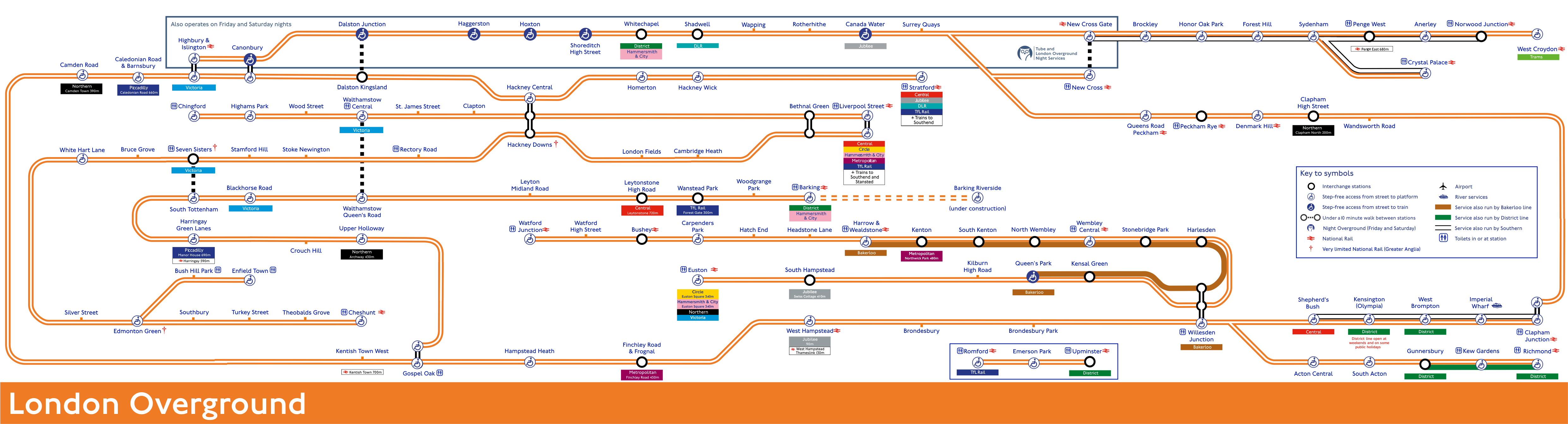
This is what they used

Line names and IDs

"1","Watford Junction to Euston","DC"
"2","Richmond to Stratford & Willesden Junction to Clapham Junction","NWLL"
"3","Gospel Oak to Barking","GOB",
"4","Highbury & Islington to West Croydon/Clapham Junction","ELL",    
"5","Liverpool Street to Edmonton Green, Enfield Town, Cheshunt & Chingford","West Anglia"
"6","Romford to Upminster","RU",

This is broken down into sub-lines (subline ID, line ID, name)

(1000, 1, 'Watford Jct DC'),
(1001, 2, 'Rchmnd-Strtfrd'),
(1002, 2, 'Wllsdn-Clphm J'),
(1003, 3, 'Gpl Oak-Brkng'),
(1005, 5, 'Enfield T WA'),
(1006, 5, 'Chingford WA'),
(1007, 5, 'Cheshunt WA'),
(1008, 6, 'Rmfrd-Upmnstr'),
(4001, 4, 'New Cross ELL'),
(4002, 4, 'Clphm Jct ELL'),
(4003, 4, 'W Croydon ELL'),
(4004, 4, 'Crystal Pal ELL'),
(9999, 4, 'ELL Core');

So that puts stations in sublines like this … -1 means “served by more than one sub-line”

"Acton Central","1001","ACC"
"Anerley","4003","ANZ"
"Barking","1003","BKG"
"Bethnal Green","-1","BET"
"Blackhorse Road","1003","BHO"
"Brockley","-1","BCY"
"Brondesbury","1001","BSY"
"Brondesbury Park","1001","BSP"
"Bruce Grove","-1","BCV"
"Bush Hill Park","1005","BHK"
"Bushey","1000","BSH"
"Caledonian Road and Barnsbury","1001","CIR"
"Cambridge Heath","-1","CBH"
"Camden Road","1001","CMD"
"Canada Water","-1","ZCW"
"Canonbury","-1","CNN"
"Carpenders Park","1000","CPK"
"Cheshunt","1007","CHN"
"Chingford","1006","CHI"
"Clapham High Street","4002","CLP"
"Clapham Junction","-1","CLJ"
"Clapton","1006","CPT"
"Crouch Hill","1003","CRH"
"Crystal Palace","4004","CYP"
"Dalston Junction","-1","DLJ"
"Dalston Kingsland","1001","DLK"
"Denmark Hill","4002","DMK"
"Edmonton Green","-1","EDR"
"Emerson Park","1008","EMP"
"Enfield Town","1005","ENF"
"Euston","1000","EUS"
"Finchley Road and Frognal","1001","FNY"
"Forest Hill","-1","FOH"
"Gospel Oak","-1","GPO"
"Gunnersbury","1001","GUN"
"Hackney Central","1001","HKC"
"Hackney Downs","-1","HAC"
"Hackney Wick","1001","HKW"
"Haggerston","-1","HGG"
"Hampstead Heath","1001","HDH"
"Harlesden","1000","HDN"
"Harringay Green Lanes","1003","HRY"
"Harrow And Wealdstone","1000","HRW"
"Hatch End","1000","HTE"
"Headstone Lane","1000","HDL"
"Highams Park","1006","HIP"
"Highbury And Islington","-1","HHY"
"Homerton","1001","HMN"
"Honor Oak Park","-1","HPA"
"Hoxton","-1","HOX"
"Imperial Wharf","1002","IMW"
"Kensal Green","1000","KNL"
"Kensal Rise","1001","KNR"
"Kensington (Olympia)","1002","KPA"
"Kentish Town West","1001","KTW"
"Kenton","1000","KNT"
"Kew Gardens","1001","KWG"
"Kilburn High Road","1000","KBN"
"Leyton Midland Road","1003","LEM"
"Leytonstone High Road","1003","LER"
"Liverpool Street","-1","LST"
"London Fields","-1","LOF"
"New Cross","4001","NWX"
"New Cross Gate","4003","NXG"
"North Wembley","1000","NWB"
"Norwood Junction","4003","NWD"
"Peckham Rye","4002","PMR"
"Penge West","4003","PNW"
"Queens Park","1000","QPW"
"Queens Road Peckham","4002","QRP"
"Rectory Road","-1","REC"
"Richmond","1001","RMD"
"Romford","1008","RMF"
"Rotherhithe","-1","ROE"
"Seven Sisters","-1","SVS"
"Shadwell","-1","SDE"
"Shepherds Bush","1002","SPB"
"Shoreditch High Street","-1","SDC"
"Silver Street","-1","SLV"
"South Acton","1001","SAT"
"South Hampstead","1000","SOH"
"South Kenton","1000","SOK"
"South Tottenham","1003","STO"
"Southbury","1007","SBU"
"St James Street","1006","SJS"
"Stamford Hill","-1","SMH"
"Stoke Newington","-1","SKW"
"Stonebridge Park","1000","SBP"
"Stratford","1001","SRA"
"Surrey Quays","-1","SQE"
"Sydenham","4003","SYD"
"Theobalds Grove","1007","TEO"
"Turkey Street","1007","TUR"
"Upminster","1008","UPM"
"Upper Holloway","1003","UHL"
"Walthamstow Central","1006","WHC"
"Walthamstow Queens Road","1003","WMW"
"Wandsworth Road","4002","WWR"
"Wanstead Park","1003","WNP"
"Wapping","-1","WPE"
"Watford High Street","1000","WFH"
"Watford Junction","1000","WFJ"
"Wembley Central","1000","WMB"
"West Brompton","1002","WBP"
"West Croydon","4003","WCY"
"West Hampstead","1001","WHD"
"White Hart Lane","-1","WHL"
"Whitechapel","-1","ZLW"
"Willesden Junction","-1","WIJ"
"Wood Street","1006","WST"
"Woodgrange Park","1003","WGR"

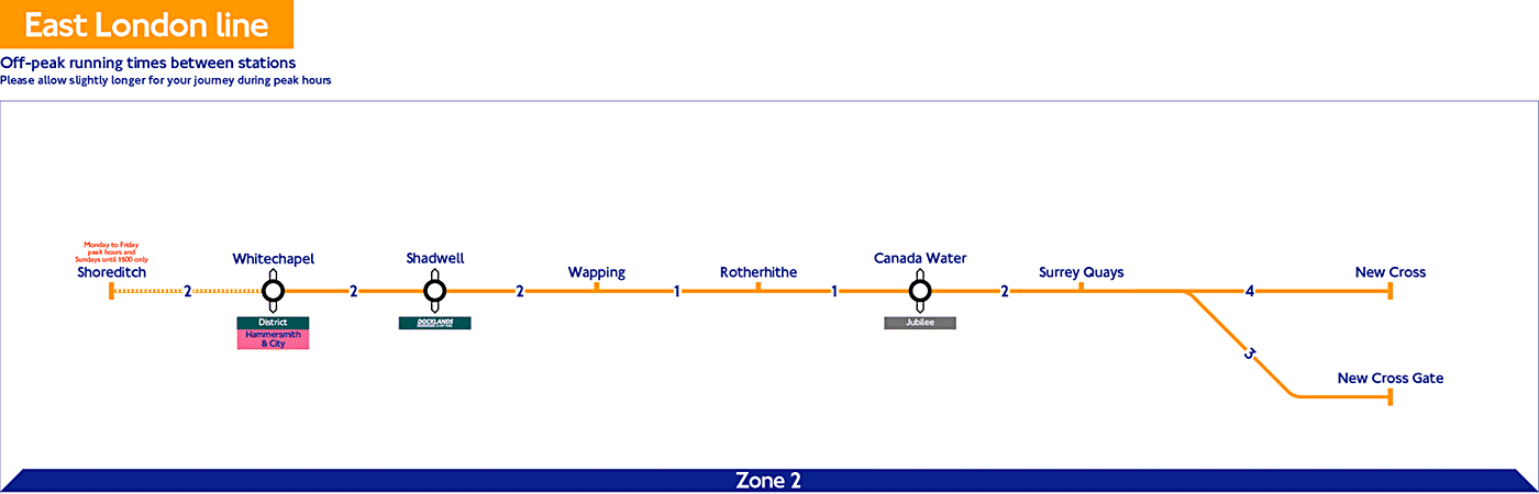
There is also a virtual line the “ELL Core” which is these stations

"DLJ","Dalston Junction"
"SQE","Surrey Quays"
"ROE","Rotherhithe"
"WPE","Wapping"
"SDE","Shadwell"
"HOX","Hoxton"
"HGG","Haggerston"
"ZCW","Canada Water"
"ZLW","Whitechapel"
"SDC","Shoreditch High Street"
1 Like

The above coding are problematic for the public because:

  • Trains that run to/from Crystal Palace are classed as W Croydon ELL until they get to Sydenham
  • Trains that run from Clphm J to Wllsdn and on to Stratford change from 1002 to 1001

There is also the existence of the 4001 New Cross ELL, which you can’t see on any diagram but you can in the timetable. These trains run from New Cross to Dalston Junction and back, acting as it was, the Old East London line.

I suspect all this overlayed complication is why they aren’t publicly used.

1 Like

I see. Then it makes sense to just return a list of all the stations.

Brian

In practice I don’t see any great difference in principle between naming and numbering lines, as long as there are not too many of them to name. If LU lines were numbered then numbering LO lines would also be sensible. LU lines are named (perhaps because the system grew out of multiple private operations); however confusing they might be to some, digging it up would confuse more. What I would not have done is leave a mass of unnamed orange spaghetti, which I don’t think helps map users, for example, and will get worse if (as often rumoured) further lines get added to the LO network. The NLL is already known to many by that name and I do not think anyone confuses it with the Northern.

This all started with the difficulty of interpreting disruption messages on LO - whether they are meant to be networkwide or very specific. It could be done by whoever (or whatever) drafts the messages thinking about what the user really needs to know but distinguishing the lines completely would build that in automatically.

As a North Londoner, I never felt confident about using Southern Region. Trains displayed headcodes but no destination. These headcodes were not used in publicity. I would be pleasantly surprised if I arrived at the right destination! Fortunately trains now display destinations and platform information is far better. They have tried colour coding lines on network maps as well though it is difficult for such an entangled network. Nor does their passenger information say “delays on South Eastern” when the issue is somewhere near Margate! The way it used to be seemed a bit Royston Vasey - these are local trains for local people - to me and anything like that seems best avoided.

@mjcarchive

I’ve been thinking about this and I suspect that the problem is that the UK rail network is that there are quite large sections of it that are for the signallers (because some of it still run that way), train drivers, support staff and only grudgingly passengers.

The whole thing is treated by some “important” people as a Victorian playset: draughty platform with no rail protections are venerated, historic platform numbers are valued, steep stairs prioritised.

To my personal mind we should be a long way down the road to trains-as-a-service. Automatic trains, automatic signals, moving block technologies.

When Covid is over then people will return but they will not find a modern anything: the ticketing system is out of date, the pricing structure in the 1970s, some of the signals are still Victorian.

Perhaps we will get a “Great Mind” to simply all this and simple effective way for the public to use it all, without having a second-rate experience.